Unity
USA California & Desert Southwest Real-World Terrains 100 km²
$13.99
$19.98
30% off
Price history
Recorded standalone sale prices and the latest available store price, in USD. Historical dots use the sale start date and its recorded offer price. Prices can change during a sale; this is not a daily price log. Bundle prices and upcoming offers are excluded. History covers up to the 100 most recent recorded offers.
Lowest recorded standalone price in this history: $13.99. The latest store price is $13.99, matching the lowest recorded price shown here.
View 4 recorded prices
| Sale start / price check | Price | Observation |
|---|---|---|
| $13.99 | Latest store price | |
| $19.98 | Unity First Price 2026-11-06 2026-11-06 | |
| $13.99 | Unity New Release Discount 2026-11-06 2026-11-20 | |
| $13.99 | Unity New Release Discount 2026-11-06 2026-11-20 |
Sale and bundle history
The 3 most recent recorded offers including this asset. Past offers may no longer be available. Bundle prices cover a package, not this asset alone.
About USA California & Desert Southwest Real-World Terrains 100 km²
- Theme > Nature & Countryside
- Theme > Realistic
- Art & Visuals > 3D
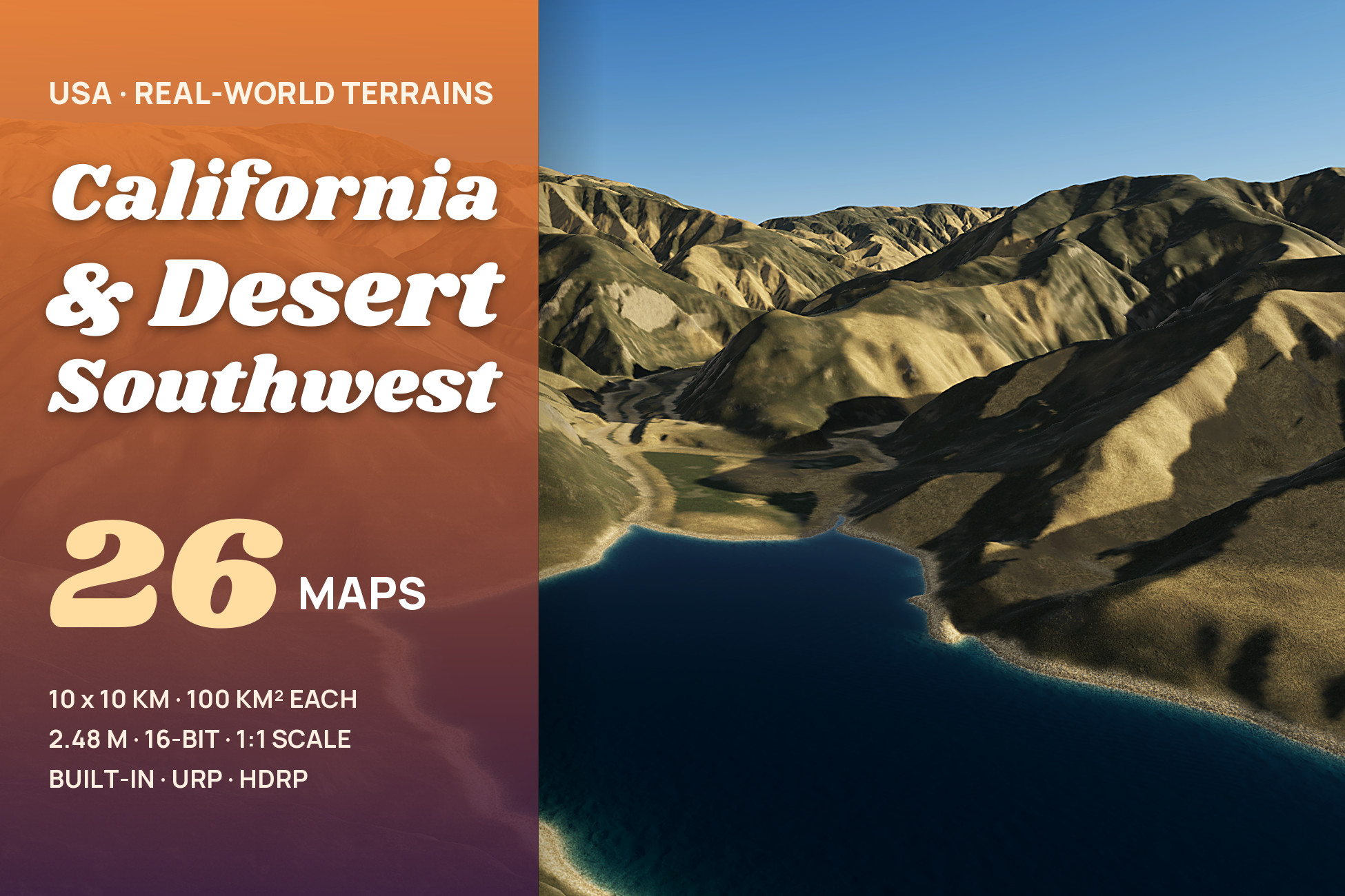
California and the desert Southwest - golden chaparral ridges, coast-range canyons with reservoirs, desert mountains, mesas and washes of Arizona and the Mojave - at their real size, 10 x 10 km per map
26 maps of California and the desert Southwest from real-world elevation data (DEM). Golden grass and dark chaparral on steep Californian ridges, coast-range canyons with winding reservoirs, and the mountains, mesas, canyons and washes of the Arizona desert. Each map covers 10.00 x 10.00 km (about 10 x 10 km, 100 square km) at 2.48 m between samples. Every Unity terrain sample is an original heightmap pixel - nothing is stretched or resampled - and 1 Unity unit is 1 metre.
WHAT'S INSIDE
- 26 heightmaps - 16-bit PNG, 4033 x 4033 px, relief from 266 m to 1,582 m per map
- One Unity terrain per map - 4097 samples at the map's own 2.48 m spacing; the unused 64-sample strip at the edge is cut away with terrain holes
- 3 demo levels x 3 render pipelines - 9 ready scenes to fly or walk through: Canyon Reservoir, Chaparral Ridges, Desert Mountains
- Terrain Builder - one click turns any heightmap into a real-scale Unity terrain
- 2 ground looks - 8 ground layers each in 4K (California Hills: meadow, forest floor, dry earth, scree, rock, gravel, bog, lake bed; Desert Southwest: meadow, forest floor, dry earth, scree, rock, gravel, pavement, lake bed)
- Shore water - transparent winding canyon reservoirs: clear at the shoreline, the bed visible in the shallows, darker water further out, rivers that follow the valley downhill, a thin moving shore film and wet ground just above the water, in Built-in, URP and HDRP
- Golden summer and desert - the ground of the demo levels is painted from the real shape of each map: dark chaparral on the shaded slopes, golden grass on the sunny ones, granite and schist outcrops, a bare ring around the reservoirs; desert scrub, grassland, red soil, sandstone walls, talus and desert pavement in the Southwest
FEATURES
- Huge real-world maps - 10 x 10 km of real ground in every map, at 2.48 m between samples: ridges, canyons, fans, washes, mesas, buttes and reservoir shorelines are in the data itself
- Exact scale - size and height range are in every file name and inside every PNG, and the builder reads them for you
- Anti-tiling terrain shaders - every layer blends three texture sizes by viewing distance, so no repeating patterns
- Cliffs without stretching - textures are projected from the side on steep faces, so walls show real rock texture instead of vertical streaks; flat ground is unchanged
- Verify - compares every terrain height with the original pixels
PERFORMANCE
- Native 3840 x 2160 - no upscaling, demo scenes in player builds: HDRP 132-160 FPS · URP 163-214 FPS · Built-in 324-541 FPS (RTX 3090)
DEMO CONTROLS
Mouse look · WASD move · Shift fast · G walk at 1.8 m eye height · F fly · N / P next / previous level · H help
UNITY 2022.3 AND ABOVE
Built-in, URP and HDRP in one package. Tools > Lidar Terrains > Project Setup switches on terrain holes, and Shore Water Setup the depth and opaque textures the water reads, in your pipeline asset with one click. The Built-in Render Pipeline has no post-processing, so the Built-in demo levels look simpler than the URP and HDRP ones.
USE CASES
Open-world games · flight and driving simulators · hiking, hunting and survival games · cinematics · terrain studies. The heightmaps also work in other tools: 16-bit PNG, north up, size and height range in the file name.
26 maps of California and the desert Southwest from real-world elevation data (DEM). Golden grass and dark chaparral on steep Californian ridges, coast-range canyons with winding reservoirs, and the mountains, mesas, canyons and washes of the Arizona desert. Each map covers 10.00 x 10.00 km (about 10 x 10 km, 100 square km) at 2.48 m between samples. Every Unity terrain sample is an original heightmap pixel - nothing is stretched or resampled - and 1 Unity unit is 1 metre.
WHAT'S INSIDE
- 26 heightmaps - 16-bit PNG, 4033 x 4033 px, relief from 266 m to 1,582 m per map
- One Unity terrain per map - 4097 samples at the map's own 2.48 m spacing; the unused 64-sample strip at the edge is cut away with terrain holes
- 3 demo levels x 3 render pipelines - 9 ready scenes to fly or walk through: Canyon Reservoir, Chaparral Ridges, Desert Mountains
- Terrain Builder - one click turns any heightmap into a real-scale Unity terrain
- 2 ground looks - 8 ground layers each in 4K (California Hills: meadow, forest floor, dry earth, scree, rock, gravel, bog, lake bed; Desert Southwest: meadow, forest floor, dry earth, scree, rock, gravel, pavement, lake bed)
- Shore water - transparent winding canyon reservoirs: clear at the shoreline, the bed visible in the shallows, darker water further out, rivers that follow the valley downhill, a thin moving shore film and wet ground just above the water, in Built-in, URP and HDRP
- Golden summer and desert - the ground of the demo levels is painted from the real shape of each map: dark chaparral on the shaded slopes, golden grass on the sunny ones, granite and schist outcrops, a bare ring around the reservoirs; desert scrub, grassland, red soil, sandstone walls, talus and desert pavement in the Southwest
FEATURES
- Huge real-world maps - 10 x 10 km of real ground in every map, at 2.48 m between samples: ridges, canyons, fans, washes, mesas, buttes and reservoir shorelines are in the data itself
- Exact scale - size and height range are in every file name and inside every PNG, and the builder reads them for you
- Anti-tiling terrain shaders - every layer blends three texture sizes by viewing distance, so no repeating patterns
- Cliffs without stretching - textures are projected from the side on steep faces, so walls show real rock texture instead of vertical streaks; flat ground is unchanged
- Verify - compares every terrain height with the original pixels
PERFORMANCE
- Native 3840 x 2160 - no upscaling, demo scenes in player builds: HDRP 132-160 FPS · URP 163-214 FPS · Built-in 324-541 FPS (RTX 3090)
DEMO CONTROLS
Mouse look · WASD move · Shift fast · G walk at 1.8 m eye height · F fly · N / P next / previous level · H help
UNITY 2022.3 AND ABOVE
Built-in, URP and HDRP in one package. Tools > Lidar Terrains > Project Setup switches on terrain holes, and Shore Water Setup the depth and opaque textures the water reads, in your pipeline asset with one click. The Built-in Render Pipeline has no post-processing, so the Built-in demo levels look simpler than the URP and HDRP ones.
USE CASES
Open-world games · flight and driving simulators · hiking, hunting and survival games · cinematics · terrain studies. The heightmaps also work in other tools: 16-bit PNG, north up, size and height range in the file name.